
Carefree Highway
Project Overview
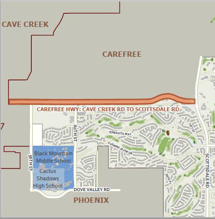
The city of Scottsdale is in the early stages of design for improvements to Carefree Highway, from Cave Creek Road to Scottsdale (Tom Darlington) Road, to improve the capacity and operational efficiency of the roadway.
This project will ultimately expand Carefree Highway from two to four lanes (two lanes in each direction) with a center landscaped raised median island and will include bike lanes, shared-use path/trail, and curb and gutter. Drainage improvements and utility work will also take place as part of the project.
Safety improvements will be made at approximately ten intersections along the project corridor. Based on traffic analysis, modifications are needed such as signals or new turn bays at most of the intersections.
The Carefree Highway Corridor serves north central Maricopa County and Scottsdale, Phoenix, Cave Creek, and Carefree. Carefree Highway west of Cave Creek Road is a four-lane roadway with a raised median and turn lanes at major intersections, but east of Cave Creek Road, the roadway transitions to a two-lane roadway until its ending at Scottsdale Road.
This project will improve Carefree Highway to this planned design which will improve travel time and reduce congestion.
Public Outreach
The following presentation is a project overview and was given at a public meeting on Feb. 12, 2024.
Carefree Highway Public Meeting PowerPoint
To view the preliminary plans please review the following segments:
- Cave Creek Road to Mountainside Drive
- Mountainside Drive to Los Reales Drive
- Los Reales Drive to Arroyo Road
- Arroyo Road to Ridgeway Drive
- Ridgeway Drive to Stagecoach Pass Road
- Stagecoach Pass Road to Scottsdale Road
Project History
Carefree Highway is classified as a future Minor Arterial by the City of Scottsdale in the 2008 Transportation Master Plan. This defines the roadway as a four-lane road with raised medians.
Also, in 2004 Maricopa Association of Governments (MAG) Regional Transportation Plan (RTP) identified the need to widen Carefree Highway between Cave Creek Road and Scottsdale Road to four lanes and programmed for construction in Phase III (FY2016 through FY2020).
The Carefree Highway is also designated as an Urban Road of Regional Significance. These roads are identified as facilities having higher design standards and higher speeds that will help ensure regional mobility.
Finally, the Carefree Highway serves as a Scenic corridor for many decades in Scottsdale, which acknowledges the need to minimize or avoid adverse impacts and preserve the corridor's environment.
FAQ
Carefree Highway is being improved to the City of Scottsdale’s current standard for a minor arterial street, which includes two travel lanes in each direction, landscaped median, bike lanes and pedestrian improvements.
A specific traffic analysis was not conducted for this project; however, this project was part of Scottsdale's Transportation Master Plan and, as part of that planning process, a traffic analysis was conducted. In the Transportation Master Plan, this corridor is designated as a minor arterial, and this project will improve the roadway as required to be compliant with the City's standard for minor arterial roadways as defined in the City's Design Standards and Policy Manual. Additionally, the regional traffic models maintained, updated and enhanced regularly by Maricopa Association of Governments (MAG) were referenced and the data was utilized for traffic purposes.
No, the posted speed limit will not be changed.
Yes, a raised landscaped median island will be constructed on Carefree Highway with turn lanes at major access points.
The City has determined that an 8’ concrete shared use path will be constructed along the south side with the project. This is consistent with the City’s arterial street typical section for this part of the city.
A 5-foot bike lane is being constructed as part of the Carefree Highway project that is consistent with city design and policy standards. Any widening or alteration would not comply with those standards.
Landscape and restoration of disturbed areas will be consistent with the plants identified on the Indigenous Plant List, which can be found on the city’s webpage, to be used in conjunction with the Environmentally Sensitive Lands Ordinance (ESLO)
No roundabouts are planned as part of this project. Previous alternatives did include the potential for a Roundabout, but it was determined to not be feasible.
Dedicated right turn lanes/pockets on the north side of Carefree Highway were considered, but will not be included since the widening from 2 to 4-lanes eliminates the requirement, and to minimize right-of-way acquisition and work within the existing city right-of-way.
For projects that expand the capacity of roadways, the City does a full noise analysis of the project limits. Existing noise levels are gathered to calibrate the model and existing and proposed traffic volumes are used to predict the noise levels that will occur after the project is constructed.
A noise analysis is being conducted which will determine if noise mitigation measures are recommended. It should be noted that the cost of the mitigation measure is also weighed against a cost per benefitted receiver, solely for those benefitting from the mitigation per the applicable standards.
A traffic signal is not warranted for the intersection of Terravita Way and Carefree Highway; however, channelization improvements have been provided.
Construction on Carefree Highway is currently scheduled to begin in 2025, based on design readiness, completion of land rights acquisitions, and funding availability.
Carefree Highway will remain open for travel during construction, with traffic lanes shifted away from the work activity and possible turn restrictions in place. While no long-term closures are anticipated, short term closures may be necessary, and will be authorized only when it has been determined to be in the best interest of the project. At times, night work may be approved to allow the contractor to complete work and mitigate the need for full day time closures.
The design team will coordinate with residents and their respective solid waste companies, as well as the US Postal Service, to address any issues related to those services during construction and once the improvements are in place. The postal service may want to install centralized cluster boxes for mail delivery. The US Postal Service will make that determination as part of the project development process.
School buses will continue to be able to stop on Carefree Highway.
Wildlife impacts as it relates to traffic was evaluated as part of the preserve improvements. The determination is that the number of traffic incidents between vehicles and large animals was minimal, and smaller wildlife can take advantage of the numerous drainage dry crossings culverts. The issue with animal crossings is that they don’t usually occur in one specific location, so the City's Transportation Department wouldn’t design for one unless there was some evidence that there was a specific wash or other corridor that was being utilized.
For residents with direct access to Carefree Highway and no median opening to permit left turns onto Carefree Highway, they should make a u-turn at the next median opening or traffic signal to safely depart/arrive at their residence.
Project Information
Budget: $11.4 million
Sponsoring Division: Transportation
Funding Source: Regional Sales Tax - Arterial Life Cycle Program and 2019 Transportation 0.1% Sales Tax
Project Location: Carefree Highway from Cave Creek Road to Scottsdale Road
480-898-4110