Carefree Highway
Project Phase
Project Summary
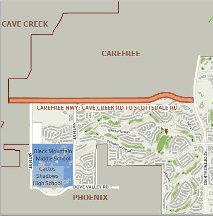
The city of Scottsdale is designing improvements to the Carefree Highway, from Cave Creek Road to Scottsdale (Tom Darlington) Road. The changes to the roadway will improve the capacity and operational efficiency. This project will ultimately expand Carefree Highway from two to four lanes (two lanes in each direction) with a center landscaped raised median island and will include bike lanes, shared-use path/trail, and curb and gutter. Drainage improvements and utility work will also take place as part of the project.
Project Information
Budget: $11,400,000
Sponsoring Division: Transportation
Additional Funding Sources: 2019 Transportation 0.1% Sales Tax
Project Location: Carefree Highway from Cave Creek Road to Scottsdale Road
Contact Information
Derek Rogers
Project Manager
480-312-7637
Derek Rogers
Project Information
The Carefree Highway Corridor serves north central Maricopa County and Scottsdale, Phoenix, Cave Creek, and Carefree. Carefree Highway west of Cave Creek Road is a four-lane roadway with a raised median and turn lanes at major intersections, but east of Cave Creek Road, the roadway transitions to a two-lane roadway until its ending at Scottsdale Road.
Safety improvements will be made at approximately ten intersections along the project corridor. Based on traffic analysis, modifications are needed such as signals or new turn bays at most of the intersections.
This project will improve Carefree Highway to this planned design in Scottsdale’s 2022 Transportation Action Plan which will improve travel time and reduce congestion.
A project specific traffic analysis was conducted to evaluate intersection capacity and develop recommendations for intersection control types, lane configuration, and storage lengths within the project limits. The traffic analysis was prepared based on criteria set forth by the City of Scottsdale’s Design Standards & Policies Manual (DSPM) as well as the requirements outlined in the project scope.
Based on the results of the study, the following improvements are planned:
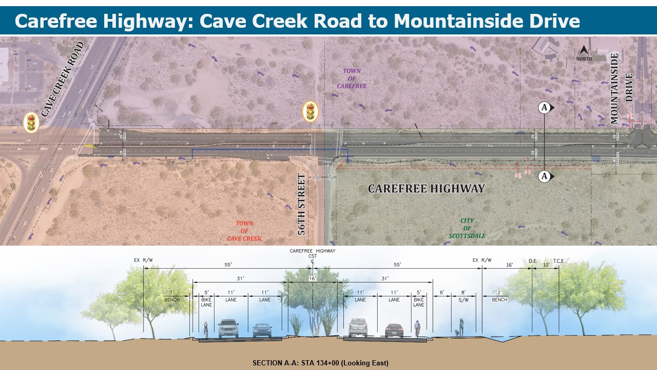
- Carefree Hwy. at Cave Creek Road: Recommendations at this intersection will be completed as part of a separate project.
- Carefree Hwy. at 56th St.: Maintain lane configuration and signal phasing.
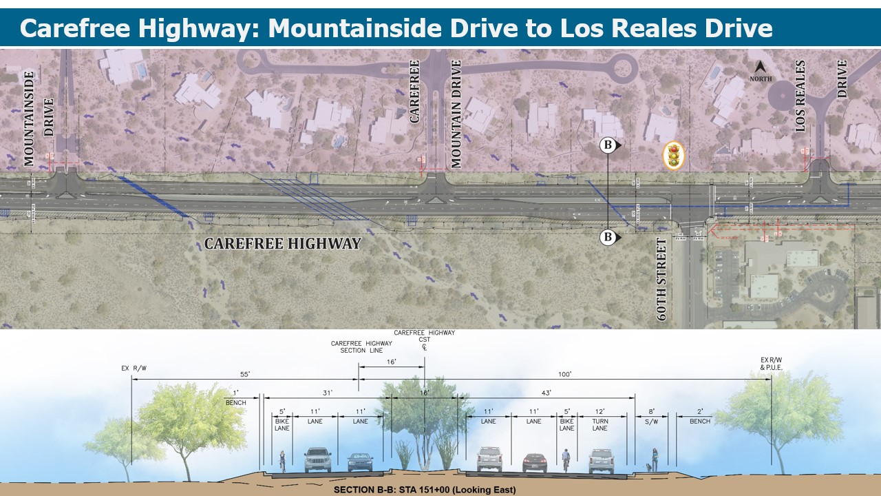
- Carefree Hwy. at Mountainside Drive: Convert westbound right turn lane into shared through/right lane.
- Carefree Hwy. at Mountain Drive: Convert westbound right turn lane into shared through/right lane.
- Carefree Hwy. at 60th St.: Extend eastbound right turn lane, provide single west bound left turn lane. Upgrade traffic signal (a roundabout was also evaluated).
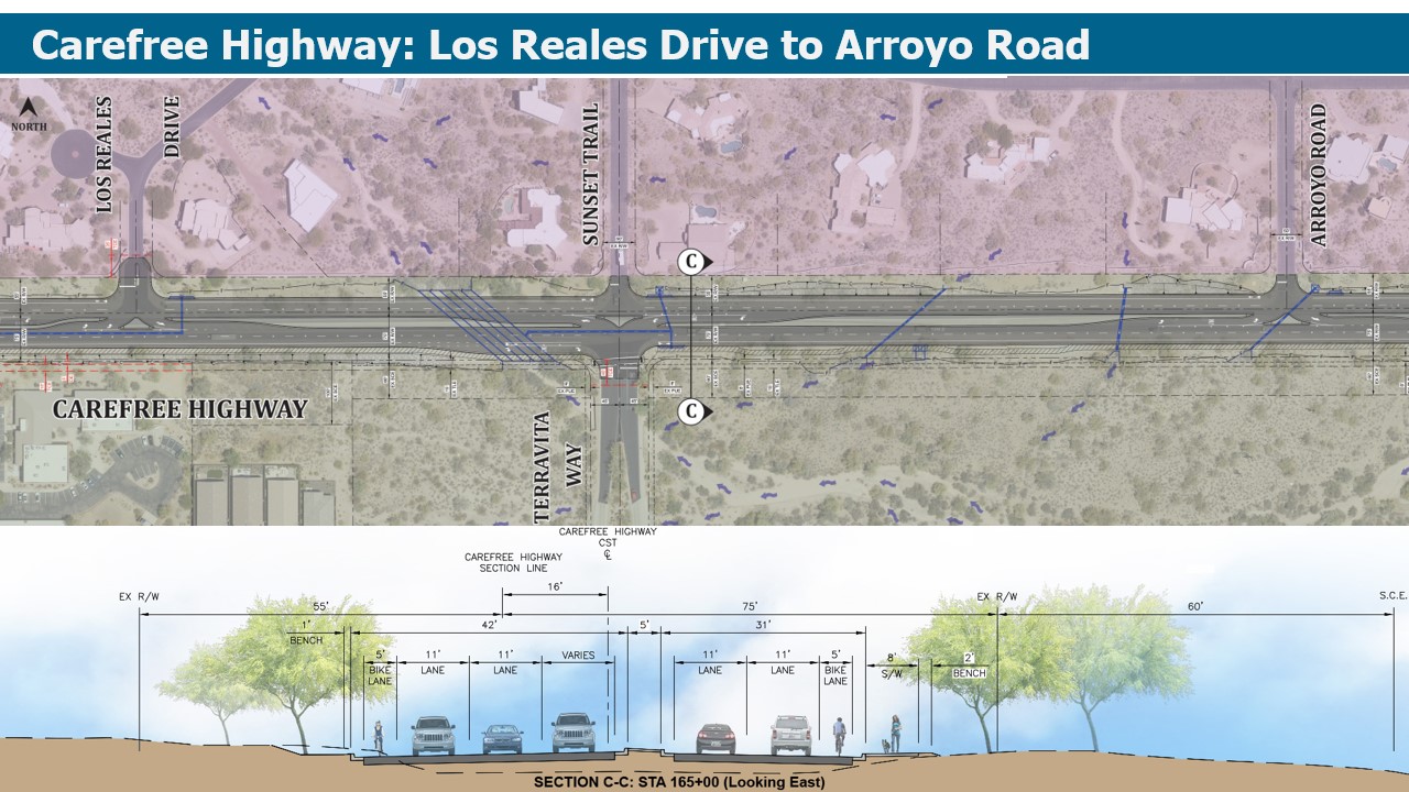
- Carefree Hwy. at Los Reales Road: Convert westbound right turn lane into shared through/right lane.
- Carefree Hwy. at Terravita Way/Sunset Trail: Acceleration lane for north bound left movement, provide west bound left turn lane, raised median to restrict south bound to right in/right out only, convert westbound right turn lane into shared through/right lane. A traffic signal warrant analysis was performed at this intersection. No warrant is mete for the 2022 (existing year), 2025 (build year) or 2045 (horizon year). Traffic volumes on Terravita Way/Sunset Trail are not high enough to meet the warrant thresholds in any analysis year. Additionally, there exists no twelve-month period in which five crashed occurred at this intersection.
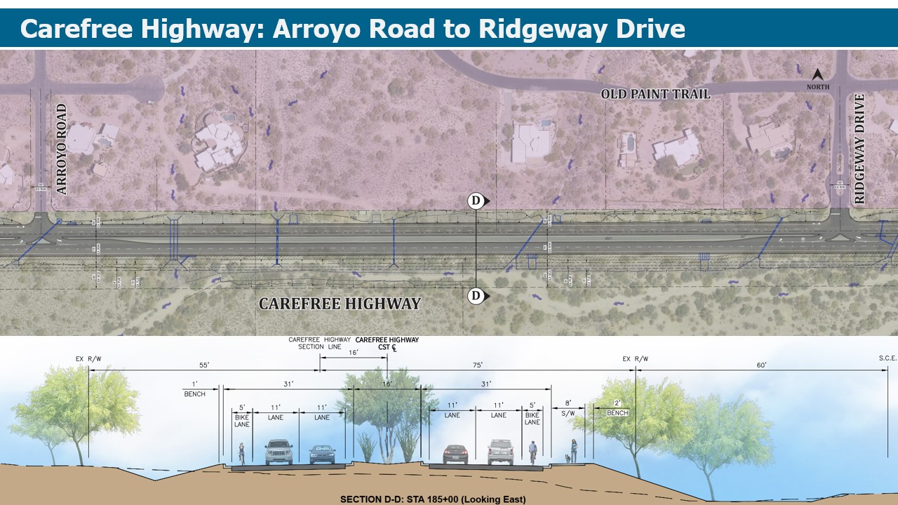
- Carefree Hwy. at Arroyo Road: Convert westbound right turn lane into shared through/right lane.
- Carefree Hwy. at Ridgeway Drive: Convert westbound right turn lane into shared through/right lane.
- Carefree Hwy. at Stagecoach Pass: Maintain existing lane configuration.
- Carefree Hwy. at Terravita Marketplace West Driveway: Maintain existing lane configuration.
- Carefree Hwy. at Scottsdale Road / Tom Darlington Drive: Recommendations at this intersection will be completed as part of a separate project.
For additional information please view the plan images provided below and review the frequently asked questions.
Carefree Highway Project Location
Public Outreach
A public meeting was held earlier this year to provide information and solicit community feedback from residents and businesses near the planned improvements. The project team used this information, as well as other feedback received through the web and email, to consider or incorporate, where possible, as the design progressed.
The following presentation is a project overview and was given at a public meeting on Feb. 12, 2024.
To view the preliminary plans please review the following segments:


Project History
Carefree Highway is classified as a future Minor Arterial by the City of Scottsdale in the 2008 Transportation Master Plan. This defines the roadway as a four-lane road with raised medians.
Also, in 2004 Maricopa Association of Governments (MAG) Regional Transportation Plan (RTP) identified the need to widen Carefree Highway between Cave Creek Road and Scottsdale Road to four lanes and programmed for construction in Phase III (FY2016 through FY2020).
The Carefree Highway is also designated as an Urban Road of Regional Significance. These roads are identified as facilities having higher design standards and higher speeds that will help ensure regional mobility.
Finally, the Carefree Highway serves as a Scenic corridor for many decades in Scottsdale, which acknowledges the need to minimize or avoid adverse impacts and preserve the corridor's environment.
Frequently Asked Questions
Why is Carefree Highway being widened?
Carefree Highway is being improved to the City of Scottsdale’s current standard for a minor arterial street, which includes two travel lanes in each direction, landscaped median, bike lanes and pedestrian improvements.
Will the speed limit change?
No, the posted speed limit will not be changed.
Will there be raised median islands on Carefree Highway?
Yes, a raised landscaped median island will be constructed on the majority of the Carefree Highway with turn lanes at major access points. However, approximately 900 feet of Carefree Highway near Stagecoach Pass will have a flush median at the same level as the roadway to accommodate access to homes on the south side of Carefree Highway.
Will there be sidewalks or a multiuse path?
An 8-foot concrete shared use path will be constructed along the south side if the Carefree Highway with road improvements. This is consistent with the city’s standards for an arterial street typical section in this part of the city.
Will there be bike lanes?
A 5-foot bike lane is being constructed as part of the Carefree Highway project. This is consistent with city design and policy standards and any widening or alteration would not comply with those standards.
What will the landscape look like?
Desert landscaping will be used throughout the corridor and any restoration of disturbed areas will be consistent with the plants identified on the Indigenous Plant List, to be used in conjunction with the Environmentally Sensitive Lands Ordinance (ESLO).
Does the project include a roundabout?
No roundabouts are planned as part of this project. Previous alternatives did include the potential for a roundabout at 60th St., but after the intersections was evaluated, it was determined to not be feasible.
Do the plans include dedicated right turns lanes into neighborhoods on the north side of Carefree Highway?
Dedicated right turn lanes/pockets on the north side of Carefree Highway were considered but will not be included in the project. The widening of the roadway from two to four-lanes will allow for right turn movements to occur safely. The decision was made based on the low volume of traffic turning right, and to minimize right-of-way acquisition, utility conflicts, and maintain more separation to existing homes in the area.
What does the city do to evaluate future noise from roadway improvements and how will the impacts be addressed?
For projects that expand the capacity of roadways, the city does a full noise analysis within the project limits. Existing noise levels are gathered to calibrate a noise model and the existing and proposed traffic volumes are used to predict the noise levels that will occur after the project is constructed.
A noise study was completed for this project, and it was determined that noise mitigation was not warranted because of the roadway improvements. The full noise analysis can be found here.
To summarize, short-term noise level monitoring was conducted within the project limits in November 2023, to depict the existing noise environment. Two measurement locations were selected to represent noise sensitive receptors at residences along the project corridor. Three 10-minute interval equivalent noise level measurements (Leq) were conducted at each site. Measured noise levels ranged from 59 to 64 decibels.
The FHWA-approved Traffic Noise Model version 2.5 was used to predict highway traffic noise and determine if consideration of noise mitigation was warranted. Future build (2045) peak-hour noise levels ranged from 51 to 71 decibels in the AM peak-hour and 51 to 70 decibels in the PM peak-hour. The ADOT NAR threshold of 66 decibels was exceeded at two residential receivers, but mitigation analysis determined that noise barriers were not warranted at these locations.
Will there be a wall or sound barrier installed along Carefree Highway?
A noise analysis was conducted which determined modeled noise levels for future conditions will not increase significantly, so no noise mitigation measures were recommended.
Will there be a traffic signal at Terravita Way and Carefree Highway?
A traffic signal warrant analysis was performed at this intersection and it was found that a signal is not warranted. However, the project will make some modifications to the intersection to make it safer.
As part of the traffic signal warrant analysis, traffic volumes on Terravita Way/Sunset Trail were analyzed for 2022 and projected for 2025 (build year) and 2045 (horizon year) are not high enough to meet the warrant thresholds in any analysis year. Additionally, no twelve-month period exists in which five crashes occurred at this intersection.
The planned modifications to this intersection are called channelization improvements and will prevent southbound to eastbound movements at Sunset Trail. Vehicles heading east will need to utilize the Arroyo Road intersection which will include an acceleration lane.
Will there be improvements to the Carefree Highway/Tom Darlington intersection?
This project does not specifically include intersection improvements for the Carefree Highway/Tom Darlington intersection; however, City of Scottsdale will soon begin design of a separate project to evaluate improvements for the intersection. Currently this project will maintain the existing configuration of Carefree Highway just west of Tom Darlington Drive with a single left turn lane for eastbound Carefree Highway to northbound Tom Darlington Drive.
When will construction begin?
Construction on Carefree Highway is currently scheduled to begin in 2025, pending design readiness, completion of land rights acquisitions and funding availability.
Will the road be closed during construction?
Carefree Highway will remain open for travel during construction, with traffic lanes shifted away from the work activity and possible turn restrictions in place. While no long-term closures are anticipated, short term closures may be necessary, and will be authorized only when it has been determined to be in the best interest of the project. At times, night work may be approved to allow the contractor to complete work and mitigate the need for full day time closures.
For residents along Carefree Highway, how will mail and trash service be addressed during construction?
The design team will coordinate with residents and their respective solid waste companies, as well as the US Postal Service, to address any issues related to those services during construction and once the improvements are in place. The postal service may want to install centralized cluster boxes for mail delivery. The US Postal Service will make that determination as part of the project development process.
How will the school bus stop on Carefree Highway with the improvements in place?
School buses will continue to be able to stop on Carefree Highway.
Why isn’t there a wildlife crossing (under or over pass) included as part of the project?
Wildlife impacts as they relate to traffic were evaluated as part of the preserve improvements. The determination was made that the number of traffic incidents between vehicles and large animals was minimal, and smaller wildlife can take advantage of the numerous drainage dry crossing culverts. The issue with animal crossings is that they don’t usually occur in one specific location, so the City's Transportation Department wouldn’t design for one unless there was evidence that a specific wash or other corridor was being utilized.
Will U-turns be permitted on Carefree Highway for those with no left turn access?
The only location with no left turn access is at Sunset Trail. For residents in the area trying to head east, they will need to take Old Paint Trail and utilize the Arroyo Road intersection which will include an acceleration lane.
Additional Project Materials
Last Updated: Feb 10, 2026