Phase 2C Corridor Plan
The city of Scottsdale has been working with a group of Preserve trail users to provide feedback and share ideas on expectations for trails in the Phase 2C area - yellow area on map (PDF) - of the Scottsdale McDowell Sonoran Preserve. The group includes equestrians, hikers, mountain bikers and trail runners familiar with this area. This group has published a final trail corridor plan for the area.
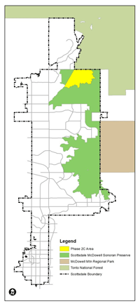
Scottsdale's McDowell Sonoran Preserve
4201 N. Hayden RoadScottsdale, AZ 85251
Last Updated: May 21, 2026